With high population density, extensive coastal development and insufficient tidal exchange with the Atlantic Ocean, the far western Long Island Sound (also known as the Western Narrows) is highly susceptible to degradation from pathogen and nutrient inputs due to stormwater runoff, combined sewer overflows, leaking septic systems and aging sewage infrastructure. This degradation leads to hypoxic (depleted dissolved oxygen) conditions in the Sound, particularly in the summer months when dissolved oxygen is at its lowest. The Long Island Sound Study Comprehensive Conservation and Management Plan (LISS CCMP 2015) identifies the Western and Eastern Narrows basins as the most stressed region of Long Island Sound. Save the Sound’s 2024 Long Island Sound Report Card gave this western-most region of the Sound a grade of "F.” This has been the grade since the report card began in 2016. In response to the increasingly critical need to document summer hypoxic conditions in western Long Island Sound and its embayments, IEC has monitored dissolved oxygen, as well as key water quality parameters relevant to hypoxia, in far western Long Island Sound every summer since 1991.
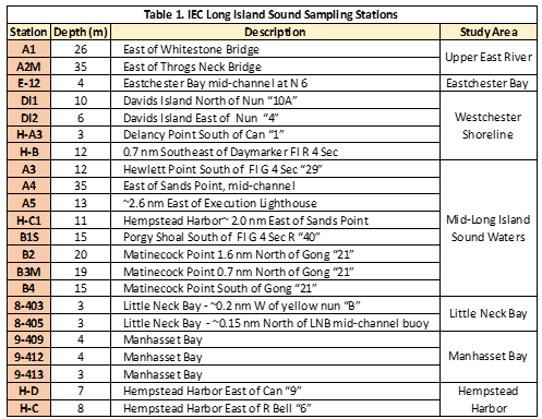
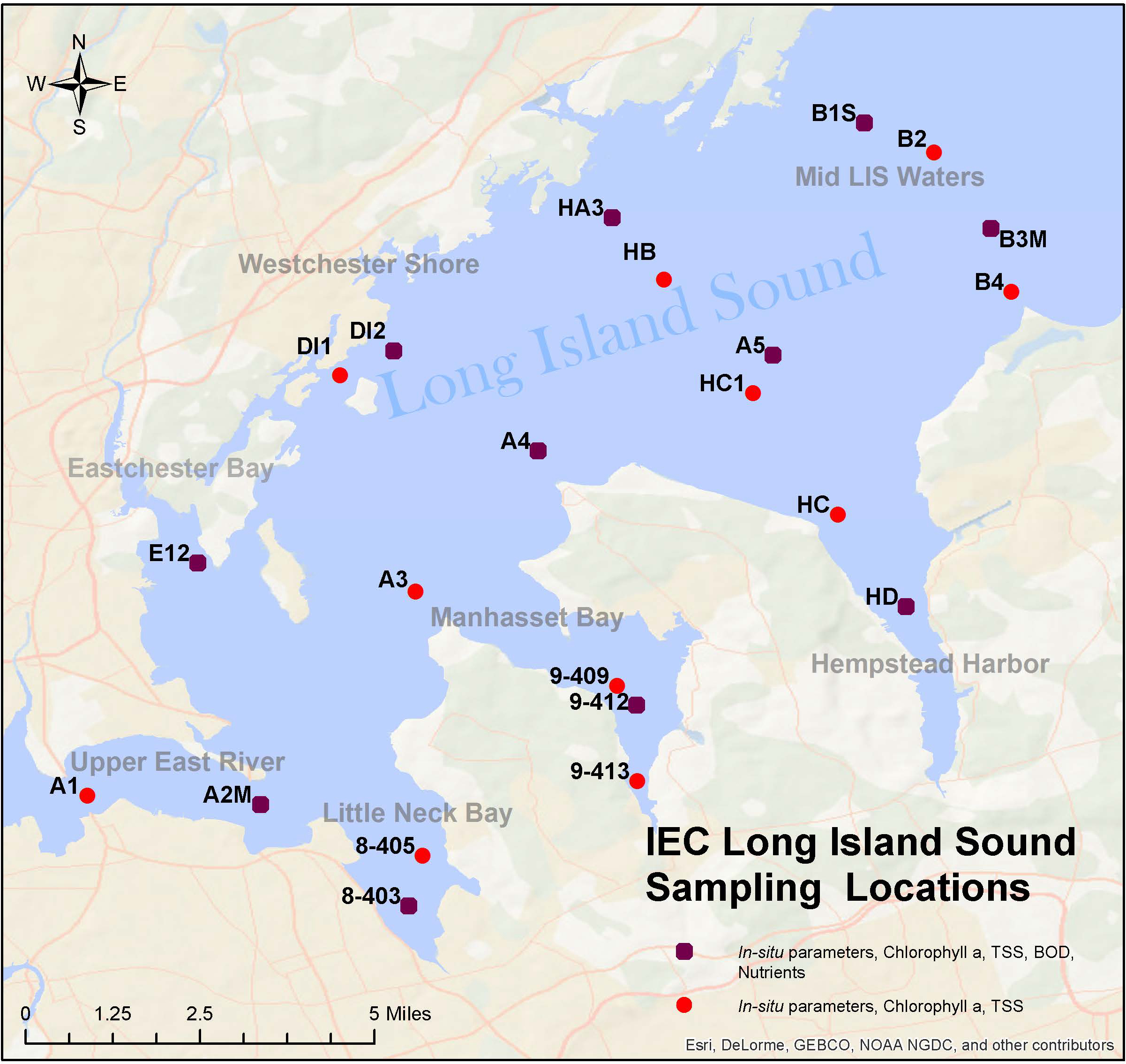
IEC’s historical 22 monitoring stations include both open water and embayment stations and cover a geographic area between the Bronx-Whitestone Bridge to the west, and runs east to a line running from approximately Rye, New York, on the Westchester County shoreline to Glen Cove, New York, on the Nassau County shoreline. See map below for exact locations of each station.
In consultation with the LISS Management Committee and the LIS Water Quality Monitoring Workgroup (WQMWG), IEC has expanded the scope of monitoring in recent years to align its monitoring program with that performed by the Connecticut Department of Energy and Environmental Protection (CTDEEP), thereby enabling a more comprehensive assessment of both the extent of hypoxia and the assessment of water quality parameters relevant to hypoxia throughout Long Island Sound. In addition, the Unified Water Study as well as the Pathogen Monitoring Network coordinated by IEC provides better data of the embayments on the Long Island Sound, assessing hypoxic conditions and pathogens, both of which are currently lacking data.
IEC’s main focus for monitoring is dissolved oxygen and key water quality indicators. This monitoring occurs weekly from late June through mid-September as this period is when the Sound is at highest risk for hypoxia. As of 2018, the Sound is also monitored year-round, and monitoring occurs monthly in the low-risk season. In addition to following hypoxic conditions, year-round sampling allows detection of temporal and spatial changes in the Sound’s open waters and embayments, as well as assessment of the effects of seasonal fluctuations in nitrogen loading on water quality parameters. During each survey, IEC monitors the following in-situ parameters at all 22 stations: dissolved oxygen, water temperature, salinity, pH, and Secchi disk depth. Biweekly, many additional parameters relating to dissolved oxygen are monitored. These parameters include chlorophyll a and Total Suspended Solids at all 22 sites, and Biochemical Oxygen Demand and nutrients (Ammonia, Nitrate+Nitrite, Particulate Nitrogen, Orthophosphate/DIP, Total Dissolved Phosphorus, Particulate Phosphorus, Dissolved Organic Carbon, Particulate Carbon, Dissolved Silica, and Biogenic Silica) at 11 sites (see map below). In October 2022, IEC also began collecting Dissolved Inorganic Carbon (DIC) and Total Alkalinity samples biweekly at these 11 sites. These two parameters are directly related to coastal acidification and support LISS efforts to better monitor coastal acidification in the Sound. During winter sampling, all parameters are monitored each run.
Data produced from IEC’s WLIS monitoring provides information to assess progress under the 2000 TMDL for dissolved oxygen and inform the EPA’s Nitrogen Reduction Strategy and NYSDEC’s Long Island Nitrogen Action Plan (LINAP). The data helps assess how the ecosystem is responding to reduced nutrient loading resulting from recent WWTP upgrades in New York and Connecticut. Additionally, the data will enable the assessment of the efficacy of various long-term control plans aimed at improving water quality in the embayments and near-shore waters in western Long Island Sound. Click here to download IEC’s historical Western Long Island Sound Water Quality database onto your device. You will need Microsoft Access or compatible software to access the database.
By collaborating with CTDEEP, the WGMWG and other Long Island Sound stakeholders, IEC and CTDEEP have been producing summer hypoxia season summaries each year since 2016. Click here for a full list of season reviews and more information. IEC will continue to work with LISS partners, specifically the LISS WQMWG and CTDEEP, to implement an efficient, coordinated monitoring program which complements the monitoring of other agencies by filling key spatial and temporal sampling gaps while minimizing any unnecessary overlap.
Funding for this project is provided through EPA Region 2 grant and the Long Island Sound Study.
Future Work:
Beginning in 2025, at the request of the Long Island Sound Office through a subaward with IEC, the Coalition to Save Hempstead Harbor will conduct water-quality monitoring of physical, chemical, and biological indicators of pollution in outer and inner Hempstead Harbor and Glen Crove Creek, Nassau County, New York. This testing will encompass 24 weeks of monitoring from May through October and include up to 21 sites. The project will carry out LISS goals of strengthening embayment monitoring and help with better policy and planning management of Hempstead Harbor. Data will be compiled in annual water quality reports.